иҮӘ然ең°зҗҶзұ» зҹҘиҜҶзӮ№
иҖғз”ҹеә”иғҪпјҡ(1)зҗҶи§Јдё»ж—ЁиҰҒд№үпјӣ(2)зҗҶи§Јж–Үдёӯе…·дҪ“дҝЎжҒҜпјӣ(3)ж №жҚ®дёҠдёӢж–ҮжҺЁж–ӯеҚ•иҜҚе’ҢзҹӯиҜӯзҡ„еҗ«д№үпјӣ(4)еҒҡеҮәеҲӨж–ӯе’ҢжҺЁзҗҶпјӣ(5)зҗҶи§Јж–Үз« зҡ„еҹәжң¬з»“жһ„пјӣ(6)зҗҶи§ЈдҪңиҖ…зҡ„ж„ҸеӣҫгҖҒи§ӮзӮ№е’ҢжҖҒеәҰгҖӮ
иҮӘ然ең°зҗҶзұ»йҳ…иҜ»жҳҜжҢҮд»Ҙж¶үеҸҠиҮӘ然ең°зҗҶзҺҜеўғзҡ„з»„жҲҗгҖҒз»“жһ„гҖҒз©әй—ҙеҲҶејӮзү№еҫҒгҖҒеҪўжҲҗдёҺеҸ‘еұ•еҸҳеҢ–规еҫӢпјҢд»ҘеҸҠдәәдёҺзҺҜеўғзӣёдә’е…ізі»ж–№йқўзҡ„ж–Үз« зҡ„ж–Үз« дёәеҹәзЎҖпјҢи®ҫи®Ўзҡ„йҳ…иҜ»зҗҶи§ЈйўҳпјҢж—ЁеңЁжҸҗй«ҳеӯҰз”ҹйҳ…иҜ»иғҪеҠӣзҡ„еҗҢж—¶пјҢеўһеҠ еӯҰз”ҹзҡ„ең°зҗҶзҹҘиҜҶгҖӮ
иҮӘ然ең°зҗҶзұ» зҹҘиҜҶзӮ№йўҳеә“
In the depths of the French Guianese rainforest, there still remain unusual groups of indigenous(еңҹи‘—зҡ„) people. Surprisingly, these people live largely by their own laws and their own social customs. And yet, people in this area are in fact French citizens because it has been a colony(ж®–ж°‘ең°) of the French Republic since 1946. In theory, they should live by the French law is often ignored or unknown, thus making them into an interesting area of вҖңlawlessnessвҖқ in the world.
The lives ofthese people have finally been recorded thanks to the effects of a Frenchman form Paris called Gin. Gin spent five months in early 2015 exploring the most remote corners of this area, which sits on the edge of the Amazon rainforest, with half its population of only 250,000 living in its capital, Cayenne.
вҖңI have a special love for the French Guianese people. I have worked there on and off for almost ten years,вҖқ says Gin. вҖңIвҖҷve been able to keep firm friendships with them. Thus I have been allowed to gain access to their living environment. I donвҖҷt see it as a lawless land. But rather I see it as an area of freedom.вҖқ
вҖңI wantedto show the audience a photographic record touching upon the uncivilized life,вҖқ continues Gin. вҖңI prefer to work in black and white, which allows me to show different specific worlds more clearly.вҖқ
His black-and-white pictures present a world almost lost in time. These pictures show people seemingly pushed into a world that they were unprepared for. These local citizens now have to balance their traditional self-supporting hunting lifestyle with the lifestyle offered by the modern French Republic, which brings with it not only necessary state welfare, but also alcoholism, betrayal and even suicide.
-
пјҲ1пјү Why does the author feel surprised about the indigenous people in French Guiana?A . They seldom follow the French law. B . They often ignore the Guianese law. C . They are separated from the modern world. D . They are both Guianese and French citizens.
-
пјҲ2пјү Gin introduced the special world of the indigenous Guianese as _________.гҖҖA . a tour guide B . a geographer C . a film director D . a photographer
-
пјҲ3пјү What is Gin's attitude towards the lives of the indigenous Guianese?
A . Cautious. B . Doubtful. C . Uninterested. D . Appreciative. -
пјҲ4пјү What does the underlined word вҖңitвҖқ in the last paragraph refer to?A . The modern French lifestyle. B . The self-supporting hunting. C . The uncivilized hunting. D . The French Republic.
If you can find a tree which has been cut downпјҢyou will see many ringsпјҢor circlesпјҢon the base of the trunk.By learning to read these ringsпјҢyou can find out about the tree's life.
The number of rings tells you how old the tree is.Each yearпјҢnew wood is formed on the outside of the tree.This new wood is light in color when the tree is growing in spring and summerпјҢand dark in winter when the tree is not growing much.SoпјҢif you count the rings of darkВӯorВӯlight colored woodпјҢyou can often find out how old the tree is.
You can also tell which years have been good years and which years have been bad years.When the lightВӯcolored rings are very wideпјҢit means that the tree has been growing quickly that year.If the rings are narrowпјҢit has been growing slowly.If the rings on a tree trunk were greatly magnifiedпјҢyou would be able to see why the rings are lightВӯcolored when the tree is growing quickly and darkВӯcolored when the tree is growing slowly.The tree trunk is made up of microscopic tubesпјҢlike some pipesпјҢcarrying water from the soilпјҢthrough the trunkпјҢand up to the leaves.They are wide and thinВӯwalled when the tree is growing quickly and they are carrying a lot of water.They are narrow and stuck together when the tree is not growing so quickly.
When a tree is oldпјҢthe tubes in the centre of the tree don't carry water.The walls of the tubes have become thick with materials which have stuck along them over the yearsпјҢforming a kind of wood calledвҖңheartwoodвҖқпјҺThis kind of wood is darker in color than the youngпјҢgrowing wood on the outside of the tree.
You don't very often see whole tree trunks which have been cut across.But once you learn to read a cross section of the woodпјҢyou can see much more in wood which has been used to make boxesпјҢhouses and other things.
In most woodпјҢinstead of seeing the trunk cut acrossпјҢyou are seeing it cut along its length.Because you don't see the whole treeпјҢyou can't tell how old it is.
Titleпјҡ of a Tree
General information | Old trees | ||
Items | Facts | Items | Facts |
Where can rings be seen | On the of a trunk | The tubes in the centre of the tree | Don't carry water |
The of rings | Helps us know about its age | The walls of the tubes | Become пјӣ Form |
lightВӯcolored rings | Show the tree grows quickly | ||
Narrow rings | Mean the tree grows slowly | ||
Microscopic tubes | Function | Carry | |
Features | Wide and when growing quickly | ||
Narrow and stuck together when growing | |||
When a wave reaches the shore, however, the water does move forward. It surges(еүҚиҝӣ )onto the shore. This is because the вҖңbottomвҖқ of the wave drags on the sand and the вҖңtopвҖқ continues on, crashing onto the shore. This crashing water is called the surf. Most waves are caused by wind blowing across the ocean's surface. The size of a wave depends on how fast and how far the wind blows over the surface and on the depth of the wave. Small winds can cause ripples, while strong winds create large hurricane waves.
Along most shorelines. water levels rise and fall twice a day. These changes, called tides. are caused by the gravitational pull of the Sun and the Moon. The ocean surface lifts, or bulges(еҮёеҮә), in two places: on the side of Earth that faces the Moon and on the side of Earth that faces away from the Moon. Both bulges cause a high tide on nearby shorelines. At the same time that the high tides occur, low tides occur between the two bulges.
Tides are also affected by the pull of the Sun, although the effect of the Sun is not as great as the effect of the Moon. When the Moon and Sun are lined up with Earth, the combined pull is the strongest, causing the highest high tides and the lowest low tides. These very high and very low tides are called spring tides. Weaker tides, called neap tides, happen when the Moon and the Sun are at right angles to Earth. High tides alternate with low tides. Along most shorelines, a high tide or low tide occurs about every six hours.
-
пјҲ1пјү The word вҖңalternateвҖқ in the last paragraph means .A . appear suddenly B . bob up and down C . change or become quickly D . happen or follow one after another
-
пјҲ2пјү The best title for the passage is .A . The Moving Ocean B . Tides and Waves C . Ocean and Earth D . Waves and Currents
Hummingbirds(иңӮйёҹ) are one of nature's most energetic fliers and the only birds to hover(зӣҳж—Ӣ) in the air by relying on their strength alone.
Now scientists have found that it is the ratio(жҜ”еҖј) of the bird's wing length to its width that makes them so efficient. The discovery is helping experts compete with 42 million years of natural selection to build helicopters that are increasingly efficient.
David Lentink, an assistant professor at Stanford University in California, tested wings from 12 different species of hummingbirds, which he sourced from museums. He placed them on a machine used to test the aerodynamics(ж°”еҠӣеӯҰ) of the helicopter blades(жЎЁеҸ¶). Professor Lentink's team used the same machine to test the blades from an advanced micro-helicopter used by the UK's army. They found that the micro-helicopter's blades are as efficient at hovering as the average hummingbirds.
But while the micro-helicopter's blades kept pace with the average hummingbird wings, they could not keep up with the most efficient hummingbird's wing. The wings of Anna's hummingbird were found to be about 27 percent more efficient than the man-made micro- helicopter's blades.
While Professor Lentink wasn't surprised at nature's superiority, he said that helicopter blades have come a long way. вҖңThe technology is at the level of an average hummingbird,вҖқ he said. вҖңA helicopter is really the most efficient hovering device that we can build. The best hummingbirds are still better, but I think it's amazing that we're getting closer. It's not easy to match their performance, but if we build better wings with better shapes, we might match hummingbirds.вҖқ
Professor Lentink said that we don't know how hummingbirds maintain their flight in a strong wind, how they navigate(зЎ®е®ҡж–№еҗ‘) through branches, or how they change direction so quickly. He thinks that great steps could be made by studying wing aspect ratios-the ratio of wing length to wing width. Understanding these abilities and characteristics could be a benefit for robotics and will be the focus of future experiments.
ж №жҚ®зҹӯж–ҮеҶ…е®№пјҢйҖүжӢ©жңҖдҪізӯ”жЎҲпјҢ并е°ҶйҖүе®ҡзӯ”жЎҲзҡ„еӯ—жҜҚж ҮеҸ·еЎ«еңЁйўҳеүҚжӢ¬еҸ·еҶ…гҖӮ
-
пјҲ1пјү What did the scientists find about hummingbirds?A . Their wings are long and wide B . They can hover in the air for a long time C . The ratio of their wing length to wing width is very important D . They are the most energetic flier in nature
-
пјҲ2пјү Which is the right order of Professor Lentink's research?
в‘ Tested wings from different species of hummingbirds
в‘ЎGot resources from museums
в‘ўAnalyzed the results and drew a conclusion
в‘ЈTested the blades from a micro-helicopter
A . в‘ в‘Ўв‘ўв‘Ј B . в‘Ўв‘ в‘ўв‘Ј C . в‘Ўв‘Јв‘ в‘ў D . в‘Ўв‘ в‘Јв‘ў -
пјҲ3пјү According to Professor Lentink, what will be the focus of future experiments?A . To know how hummingbirds can fly in a strong wind B . To know how hummingbirds change direction so quickly C . To develop a new kind of helicopter D . To study the secrets of hummingbirds
Today, the world's diversity (еӨҡж ·жҖ§) of food crops is quickly decreasing. But scientists around the world are taking action. They are building seed banks. At seed banks, scientists store the seeds of many different crops.
There are now 1,400 seed banks around the world. However, some banks are in warm countries. If the electricity fails, the seeds will get too hot and die. Other seed banks are in countries troubled by war. Sometimes people damage the seed banks. If this happens, valuable seeds can be lost forever!
The organization Global Crop Diversity Trust decided they wanted to deal with this problem. So, they decided to build a global seed bank. This seed bank would contain a back-up, or extra copy, of all the world's seeds. Smaller seed banks would still collect and keep local seeds. But they would also send copies of their seeds to the global bank.
Scientists from the Global Crop Diversity Trust chose the cold, snowy mountains of Svalbard, Norway to build the global seed bank вҖ” the Svalbard Global Seed Vault (ж–Ҝз“Ұе°”е·ҙе…Ёзҗғз§Қеӯҗеә“). Organizations, farmers, or local seed banks store their extra seeds there. And the people who place their seeds in the vault are the only people who can take them out. They pay to ship their seeds to Norway, but it does not cost them any money to store their seeds. The Global Crop Diversity Trust pays for this.
Cary Fowler is a scientist who heads the Global Crop Diversity Trust. He said, вҖңIf the Seed Vault simply supplies seed banks with copies of seeds that those banks lost by accident, the Seed Vault will be worth more than it cost.вҖқ
-
пјҲ1пјү Seed banks are built to ______.A . research on seeds B . produce new seeds C . protect crop diversity D . increase the number of seeds
-
пјҲ2пјү Compared with other seed banks, the global seed bank ______.A . was built by the government B . is more welcomed by farmers C . is mainly used by great scientists D . can provide a good environment for seeds
-
пјҲ3пјү What can we learn about the Svalbard Global Seed Vault?A . It helps to pay the shipping cost. B . No one can take seeds out of there. C . There are no fees to store seeds there. D . It mainly receives seeds from farmers.
-
пјҲ4пјү What is Cary Fowler's attitude towards the Seed Vault?A . He feels it is very important. B . He is surprised at it. C . He thinks it costs too much. D . He is uncertain about it.
Terrible disasters in the last 50 or 100 years have become increasingly common. Over the last 30 years, the number of weather-related disasters has increased quickly, and the disasters have also affected more people and caused more economic loss. However, much of this could be avoided through disaster risk reduction(DRRйҷҚдҪҺзҒҫйҡҫйЈҺйҷ©).
A meeting, held in Sendai, Japan last month, opened one day after Cyclone PamпјҲйЈ“йЈҺPamпјүhit Vanuatu, which struck the islands with winds of up to 340km/h and destroyed the island nation. The speech by the President of Vanuatu was given shortly after that. He begged the international community for support and stronger commitment (жүҝиҜә)to helping them manage climate and disaster risks. In the face of disasters, it is always the developing countries that suffer most. Damage in these countries is often worse and unluckily, there is limited money and technique to prevent these disasters.
In fact, we have seen Asian countries-especially those that have suffered a lot in disasters can't pay the price. Great loss Asia has suffered comes to a total of almost $ 53 billon yearly over the past 20 years.
At the same time, studies have shown once again that proper prevention saves lives and damage. With this in mind, people at the Sendai meeting were able to come up with new agreements that effective ways of disaster risk reduction will be carried out in the coming years for those who easily get damaged in disasters.
-
пјҲ1пјү According to the first paragraph, disasters ________.A . can all be prevented B . have become more frequent C . are all weather-related ones D . affect fewer people than before
-
пјҲ2пјү We can know from the passage that_______.A . The Sendai meeting was held one day after a cyclone hit Vanuatu B . Vanuatu was terribly destroyed by an earthquake C . The president of Vanuatu begged his country to prevent the disaster D . Vanuatu is a small island in Japan
-
пјҲ3пјү Which of the following can be the title of this news report?A . Proper ways that save lives and damage have come up. B . The Sendai meeting has made new commitments. C . Natural disasters have become more common. D . Some natural disasters can be reduced and avoided.
Glacier Bay is one of the most famous parks in America, located in the state of Alaska. This park in the southeastern part of the state covers more than 1 million hectares of Alaskan wilderness. It includes mountains, glaciers (еҶ°е·қ), bays, and even rainforests. Glacier Bay supports hundreds of kinds of animals, including many species of birds, fish, bears, whales and sea lions.
As its name suggests, much of Glacier Bay National Park is covered by glaciers. A glacier is a large area of ice that moves slowly down a slope (ж–ңеқЎ) or valley, or over a wide area of land. Glaciers cover more than 5,000 square kilometers of the park.
Glacial ice has shaped the land over the last seven million years. The glaciers found in the park today are what remains from an ice advance known as the Little Ice Age. That period began about 4,000 years ago.
During the Little Ice Age, the cold weather caused the ice to grow and advance. That situation continued until about 1,700s, when the climate began to warm. The higher temperatures caused the ice to start melting. That melting led the huge glacier to separate into more than 1,000 different glaciers.
The extremely tall and jagged (еҸӮе·®дёҚйҪҗзҡ„) mountains seen in Glacier Bay National Park were formed by the ice advancing and then melting over time. The melting of the ice also created water that filled in and created the many fjords (еіЎж№ҫ) within the park. Fjords are narrow parts of the ocean that sit between cliffs or mountains.
The huge amount of water from the melted ice killed off many kinds of plants. Vegetation returned to the area over the next 200 years. The regrowth in plants also brought back many animals to the land. This return of life to Glacier Bay is why it is sometimes called вҖңa land rebornвҖқ by people.
-
пјҲ1пјү What is mentioned in Paragraph 1?A . The function of Glacier Bay. B . The climate of Glacier Bay. C . The area of Alaskan wilderness. D . The number of animals in Glacier Bay.
-
пјҲ2пјү What happened to Glacier Bay during the Little Ice Age?A . Many slopes or valleys came into being. B . The glaciers grew and advanced. C . Different glaciers became a whole one. D . The fjords became narrow.
-
пјҲ3пјү What is mainly discussed in the last paragraph?A . How the water killed off the plants. B . When vegetation returned to Glacier Bay. C . What the relationship between plants and animals is. D . Why Glacier Bay is sometimes called вҖңa land rebornвҖқ.
Scotland has long been characterized as a land of romance. It contains ruins of many ancient castles and abbeysпјҢand there is an attractive beauty in its mountainsпјҢlong deep valleysпјҢand ribbon lakes.Each year those things attract a great number of tourists.
Numerous islands line the coast.In the north are two large groupsпјҢthe Orkney Islands and the Shetland Islands.Close to the west coast are the Inner and Outer Hebrides groupsпјҢand the islands of Arran and Bute.
The land may be divided into three regions: the Highlands in the northпјҢthe Central Lowlands and the Southern Uplands.
The Highlands are wild and picturesque(еҰӮз”»зҡ„)пјҺ A long valley called Glenmore crosses the Highlands from southwest to northeast.
In the south of the Highlands are the Grampian MountainsпјҢhighest in the British Isles. Ben NevisпјҢthe highest peakпјҢrises to 1,243 meters.Ben Lomond rises from the shore of Loch LomondпјҢScotland's largest freshwater lake.
The Central Lowlands run from southwest to northeast and the greatest length is nearly 145 kilometers.The soil here is fertileпјҢand there are four coalfields underlying the area.In the east is EdinburghпјҢScotland's historic capital cityпјҢand in the west is Glasgow. Almost 90 percent of Scotland's population live in the Lowlands.
In the Southern Uplands, the hills are generally less than 600 meters high. Their rounded or flat tops are often capped with dark peat(жіҘзӮӯ). Along the slopes are plants like grass and heather(зҹіеҚ—иҠұ).
-
пјҲ1пјү According to the text, all the following things attract many tourists to Scotland EXCEPT ________.A . ruins of ancient castles and abbeys B . mountains and valleys C . various animals and plants D . ribbon lakes
-
пјҲ2пјү From the passage we know that ________.A . Scotland's islands mainly lie in the north B . the Highlands have rich soil C . Ben Lomond is near Scotland's largest freshwater lake D . the Shetland Islands lie on the west coast of Scotland
-
пјҲ3пјү Most Scottish people live in ________.A . the Highlands B . the Central lowlands C . the Southern Uplands D . the Orkney Islands
-
пјҲ4пјү The author's aim of writing this passage is ________.A . to attract people to visit Scotland B . to describe the beautiful scenery of Scotland C . to show people the history of Scotland D . to introduce Scotland generally
The first Europeans to occupy Canada's Prince Edward Island were the French in the 1500s. At that time, its name was Ile Saint-Jean. When the British took over in 1758, they changed the name to its current one in honor of Prince Edward, the first son of Britain's King George в…ў.
Today many communities find their places in Prince Edward Island, but Charlottetown is the only one that can call itself a metropolitan(еӨ§йғҪеёӮ)area, despite the fact that it is a small one. About 60,000 people live in the city and surrounding area. The city's center area remains relatively unchanged from its 19th century beginnings. Charlottetown's boardwalk runs alongside the water, past docks, boats, shops and restaurants. Historic homes line the streets. During summer months, costumed characters walk around the city and tell of it history.
Cavendish beach welcomes beach lovers. The gulf streams makes the water warm and wonderful for swimming, and the island's 1,760-kilometer coastline means a beach is never far away.
Nine of PEI's 63 lighthouses will welcome visitors in the summer. Besides enjoying stunning views from the tops, visitors can browse in the small museums and learn about the island's history.
The most popular time to visit PE I is July to August, when the average temperature reaches 23в„ғ during the day. From January to February, the average daytime high is only -3.3в„ғ. Each winter, an average 318.2 centimeters of snow fall on the island, covering it with a white blanket.
Considering the island's many visitors, it's no surprise that tourism is important there. Other key industries on the island are agriculture, fishing and information technology. With so much to offer, the island is naturally a desirable place to live as well.
-
пјҲ1пјү What does this island's current name refer to ?A . A legendary story about its founder B . A member of the British royal family. C . A central province of Canada. D . A fine victory over the French.
-
пјҲ2пјү According to this article, how do other communities compare with Charlottetown?A . There are nearly double its size. B . They are slightly larger. C . They are approximately the same size. D . They are much smaller.
-
пјҲ3пјү Where can people walk in Charlottetown according to Paragraph 2?A . Across the highway. B . Through a field. C . Beside a harbor. D . Around a factory.
-
пјҲ4пјү Which of the following conclusions can we draw from the text?A . This article mainly describes the island's climate. B . This article implies that farming is an important industry on the island. C . All PEI's lighthouses are open to visitors in summer. D . All PEI's museums are too small to attract visitors.
Recently, we have already shown that climate change has led to a dramatic increase in storm surge risk in New York City, making devastating events like Hurricane Sandy more likely.
What can we say about the role of climate change in the unprecedented disaster that is unfolding in Houston with Hurricane Harvey? There are certain climate change-related factors that we can, with great confidence, say worsened the flooding.
Sea Level rise attributable to climate change-some of which is due to coastal subsidence(дёӢжІү) caused by human disturbance such as oil drilling-is more than half a foot(15cm) over the past few decades. That means the storm surge was half a foot higher than it would have been just decades ago, meaning far more flooding and destruction.
In addition to that, sea surface temperatures in the region have risen about 0.5C(close to 1F) over the past few decades from roughly 30C(86F) to 30.5C(87F), which contributed to the very warm sea surface temperatures(30.5-31C, or 87-88F). There is a simple thermodynamic(зғӯеҠӣеӯҰзҡ„) relationship known as the Clausius-Clapeyron equation that tells us there is a roughly 3% increase in average atmospheric moisture content for each 0.5C of warming. Sea surface temperatures in the area where Harvey intensified were 0.5-1C warmer than current-day average temperatures, which translates to 1-1.5C warmer than вҖңaverageвҖқ temperatures a few decades ago. That means 3-5% more moisture(ж°ҙеҲҶ) in the atmosphere. That large amount of moisture creates the potential for much greater rainfalls and greater flooding. The combination of coastal flooding and heavy rainfall is responsible for the devastating flooding that Houston is experiencing.
Not only are the surface waters of the Gulf of Mexico unusually warm right now, but there is a deep layer of warm water that Harvey was able to feed upon when it intensified at near record pace as it neared the coast. Human-caused warming is penetrating down into the ocean. It's creating deeper layers of warm water in the Gulf and elsewhere. Harvey was almost certainly more intense than it would have been in the absence of human-caused warming, which means stronger winds, more wind damage and a larger storm surge.
Finally, the more tenuous but potentially relevant climate factors: part of what has made Harvey such a devastating(жҜҒзҒӯжҖ§зҡ„) storm is the way it has stalled near the coast. It continues to strike Houston and surrounding regions with a seemingly endless flood, which will likely top out at nearly 4ft(1.22m) of rainfall over a days-long period before it is done. The stalling is due to very weak prevailing winds, which are failing to steer the storm off to sea, allowing it to spin around and wobble back and forth. This pattern, in turn, is associated with a greatly expanded subtropical high pressure system over much of the US at the moment, with the jet stream pushed well to the north. This pattern of subtropical expansion is predicted in model simulations of human-caused climate change. More tenuous(еҫ®ејұзҡ„), but possibly relevant still, is the fact that very persistent, nearly вҖңstationaryвҖқ summer weather patterns of this sort, where weather anomalies(both high-pressure dry hot regions and low-pressure stormy/rainy regions) stay locked in place for many days at a time, appears to be favoured by human-caused climate change.
In conclusion, while we cannot say climate change вҖңcausedвҖқ Hurricane Harvey, what we can say is that it exacerbated several characteristics of the storm in a way that greatly increased the risk of damage and loss of life. Climate change worsened the impact of Hurricane Harvey.
-
пјҲ1пјү What's the main purpose of writing the passage?A . To offer tips on climate change B . To advocate paying more attention to current climate change urgently C . To share experiences on avoiding climate change D . To criticize human-caused climate change
-
пјҲ2пјү The underlined word вҖңintensifiedвҖқ in Paragraph 4 probably means .A . worsened B . caused C . favoured D . increased
-
пјҲ3пјү What is the best title for the passage?A . Climate change made Hurricane Harvey more deadly B . Sea level rise sea and surface temperatures changed Hurricane Harvey C . Hurricane Harvey and its characteristics D . The climate change-related factors and human-caused warming
-
пјҲ4пјү Which of the following shows the development of ideas in this passage?
I: Introduction CP: Central point P: Point Sp: Sub-point(ж¬ЎиҰҒзӮ№) C: Conclusion
A .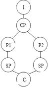 B .
B . 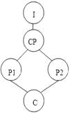 C .
C . 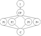 D .
D . 
The Golden Gate Bridge in San FranciscoпјҢCalifornia is one of the world's most beautiful bridges. It is also one of the most visited places in the world. More than 1800 hundred million vehicles have used the bridge since it opened more than 70 years ago.
The bridge was painted вҖңInternational OrangeвҖқ because that color went well with the natural surroundings. The color also is easier to see in the heavy fog that often covers the area. But the Golden Gate Bridge was not named for its orange color. It was named for the body of water that it crosses, the Golden Gate Strait, which is the entrance to the San Francisco Bay from the Pacific Ocean
Planning for the bridge began in the 1920s when the area around San Francisco was growing. People living in the area needed another way to get to the city besides small ferries. Joseph Strauss was the chief engineer for the project. Work began in 1934.Mr.Strauss demanded the strongest safety protections in the history of bridge building. These included the first use of вҖңhard hatsвҖқ to protect the workers' heads and special glasses to protect their eyes. A special safety net was suspended under the bridge. This net saved the lives of 19 men during the construction.
The Golden Gate Bridge opened in 1937.It extends 1280 meters across the water. The total length is 2737 meters. It was the largest suspension bridge(еҗҠжЎҘ)in the world until 1964.That is when the Verrazano Narrows Bridge opened in New York City. Today, the Golden Gate Bridge is the ninth longest suspension bridge in the world.
-
пјҲ1пјү What was the Golden Gate Bridge named after?A . The Strait it crosses B . The color of a paint C . The local climate D . Its natural surroundings
-
пјҲ2пјү How did people cross the Golden Gate Strait before the bridge was built?A . By plane. B . By train. C . By road. D . By boat.
-
пјҲ3пјү Why was a special safety net suspended under the bridge?A . Because it can protect the environment B . Because it can prevent workers from falling C . Because it can make construction easier D . Because it can save building materials from falling
-
пјҲ4пјү What do we know about Joseph Strauss?A . He built the first suspension bridge in the world. B . His safety measures were not of practical value. C . He attached importance to the workers' safety. D . He demanded strong measures to ensure the safety of the bridge.
The Sahara Festival is a celebration of the very recent past. The three-day event is not fixed to the same dates each year, but generally takes place in November or December. It is well attended by tourists, but even better attended by the locals.
During the opening ceremonies, after the official greetings from the government leaders, people who attend the festival begin to march smartly before the viewing stands, and white camels transport their riders across the sands. Horsemen from different nations display their beautiful clothes and their fine horsemanship. One following another, groups of musicians and dancers from all over the Sahara take their turn to show off their wonderful traditional culture. Groups of men in blue and yellow play horns and beat drums as they dance in different designs. On their knees in the sand, a group of women in long dark dresses dance with their hair: their long, dark, shiny hair is thrown back and forth in the wind to the rhythm of their dance.
The local and visiting Italian dogs are anxious to run after hares. The crowd is on its feet for the camel races. Camels and riders run far into the distance, and then return to the finish Line in front of the cheering people.
Towards the evening, there comes the grand finale of the opening day, an extremely exciting horserace. All the riders run very fast on horseback. Some riders hang off the side of their saddlesпјҲ马йһҚпјү. Some even ride upside downвҖ”their legs and feet straight up in the airвҖ”all at full speed. Others rush down the course together, men arm in arm, on different horses. On and on they went. So fast and so wonderful!
-
пјҲ1пјү The Sahara Festival is a festival which _____.A . has a very long history in North Africa B . is held in the same place on the same day C . is attended mainly by the people in the Sahara D . is celebrated mostly by travelers from different countries
-
пјҲ2пјү Before the races begin, _____ take part in the activities during the opening ceremonies.A . musicians, dancers, horses and hares B . camel riders, musicians, dogs and hares C . horsemen, dancers, camels and dogs D . musicians, officials, camels and horses
-
пјҲ3пјү The underlined word вҖңfinaleвҖқ in the fourth paragraph most probably means the _____ of the opening day.A . first part B . last part C . middle D . whole
-
пјҲ4пјү This passage mainly tells readers _____.A . how animals race on the first and the last days of the Sahara Festival B . how people celebrate during the three-day Sahara Festival C . what takes place at the closing ceremonies of the Sahara Festival D . what happens on the opening day of the Sahara Festival
How could we possibly think that keeping animals in cages in unnatural environments вҖ•mostly for entertainment purposes вҖ•is fair and respectful?
Zoo officials say they are concerned about animals. However, most zoos remain вҖңcollectionsвҖқ of interesting вҖңthingsвҖқ rather than protective habitats. Zoos teach people that it is acceptable to keep animals bored, lonely, and far from their natural homes.
Zoos claim to educate people and save endangered species, but visitors leave zoos without having learned anything meaningful about the animals' natural behaviour, intelligence, or beauty. Zoos keep animals in small spaces or cages, and most signs only mention the species' name, diet, and the natural range (еҲҶеёғеҢә).The animals' normal behaviour is seldom noticed because zoos don't usually take care of the animals' natural needs.
The animals are kept together in small spaces, with no privacy and little opportunity for mental and physical exercise. This results in unusual and self-destructive behaviour called zoochosis. A worldwide study of zoos found that zoochosis is common among animals kept in small spaces or cages. Another study showed that elephants spend 22 percent of their time making repeated head movements or biting cage bars, and bears spend 30 percent of their time walking back and forth, a sign of unhappiness and pain.
Furthermore, most animals in zoos are not endangered. Captive breeding (еңҲе…»з№Ғж®–)of endangered big cats, Asian elephants, and other species has not resulted in their being sent back to the wild. Zoos talk a lot about their captive breeding programmes because they do not want people to worry about a species dying out. In fact, baby animals also attract a lot of paying customers. Haven't we seen enough competitions to name baby animals?
Actually, we will save endangered species only if we save their habitats and put an end to the reasons why people kill them. Instead of supporting zoos, we should support groups that work to protect animals' natural habitats.
-
пјҲ1пјү How would the author describe the animals' life in zoos?A . Dangerous. B . Unhappy. C . Natural. D . Easy.
-
пјҲ2пјү What does the author try to argue in the passage?A . Zoos fail in their attempt to save animals. B . Zoos are not worth the public support. C . Zoos should treat animals as human beings. D . Zoos use animals as a means of entertainment.
-
пјҲ3пјү The author tries to persuade readers to accept his argument mainly by_____.A . pointing out the faults in what zoos do B . giving examples of animals in the wild C . questioning the way animals are protected D . discussing the advantages of natural habitats
-
пјҲ4пјү Although he argues against zoos, the author would still agree that______.A . zoos have to keep animals in small cages B . most animals in zoos are endangered species C . some endangered animals are reproduced in zoos D . it's acceptable to keep animals away from their habitats
йҳ…иҜ»дёӢеҲ—зҹӯж–ҮпјҢд»ҺжҜҸйўҳжүҖз»ҷзҡ„еӣӣдёӘйҖүйЎ№пјҲAгҖҒBгҖҒCе’ҢDпјүдёӯпјҢйҖүеҮәжңҖдҪійҖүйЎ№гҖӮ
If the crust (еӨ–еЈі) of the earth were not pretty solid (еқҡеӣәзҡ„), it would be shaking about and moving up and down frequently. However, there are places in the rocks of the earth's crust where it isn't strongly held togetherвҖ”where faults exist. Along the faults, one rock might push against another with great force. The energy is changed to vibration in the rocks, so they begin to shake and we have an earthquake!
The most famous one in North America was the San Francisco earthquake of 1906. Seven hundred people died and property (иҙўдә§) damage amounted to about $425,000,000.The greatest destruction came from the fires that followed the quake.
One of the most famous earthquakes in Europe took place in Lisbon, Portugal, in 1755. The city was destroyed and at least thirty thousand people were killed. In 1908, in Calabria and Sicily, a quake killed about seventyВӯfive thousand people. In 1915, in central Italy, hundreds of towns and villages were damaged and thirty thousand people were killed.
Two great earthquakes that caused great damage in Asia took place in Tokyo, Japan, and in Gansu Province in China. The Tokyo quake of 1923 killed more than one hundred thousand people and destroyed the city and the city of Yokohama, too. The Chinese quake in 1920 covered more than three hundred square miles and killed about two hundred thousand people.
-
пјҲ1пјү The first paragraph mainly tells us ________.A . where earthquakes happen B . how earthquakes happen C . the damage caused by earthquakes D . famous earthquakes in the world
-
пјҲ2пјү The underlined word вҖңvibrationвҖқ in the first paragraph probably means вҖң_______вҖқ.A . shaking B . force C . energy D . losing
-
пјҲ3пјү Which of the following earthquakes killed the most people?A . The San Francisco earthquake. B . The earthquake in Lisbon, Portugal. C . The earthquake in Calabria and Sicily. D . The earthquake in central Italy.
-
пјҲ4пјү According to the passage, we can learn that ________.A . the earth's crust in Europe is weaker than that in other places B . there were 75,000 people killed in the San Francisco earthquake C . the city of Yokohama was not greatly influenced by the Tokyo quake D . the fires following the San Francisco earthquake caused more damage than the earthquake did
Yellowstone Weather
Yellowstone National Park is at high altitude. Most of the park is above 7,500 feet (2,275 meters).
Yellowstone's weather is unpredictable. In summer, it may be warm and sunny with temperatures in the high 70s. At night in any given month, the temperature may drop close to freezing. So it is best to come prepared for cold evenings and mornings, especially if you are camping or hiking. When you leave your campsite, please leave it prepared for possible thundershowers and wind.
A sunny warm day may become fiercely stormy with wind, rain, sleet and sometimes snow. Without enough clothing, and easy day hike or boat trip can turn into a battle for survival.
Seasonal Weather Information | |
Spring Cold and snow continue into May, although temperatures gradually climb. Early in spring, daytime temperatures average in the 40s to 50s; by late May and June, they may reach the 60s and 70s. Nighttime lows fall below freezing. | Summer Daytime temperatures are usually in the 70s, occasionally reaching the 80s in the lower elevations. Nights are cool; temperatures may drop in the 40s and 30sвҖ”sometimes even the 20s. June can be cool and rainy; July and August tend to be somewhat drier, although afternoon thundershowers are common. |
Fall Weather can be pleasant, although temperatures average 10вҖ”20 degrees lower than summer readings. Nighttime lows can fall into the teens and lower. Snowstorms increase in frequency as the weeks go by or towards the end of the fall season. | Winter Temperatures often stay near zero throughout the day, occasionally reaching high in the 20s. Suhzero nighttime lows are common. Annual snowfall averages nearly 150 inches in most of the park. At higher places, 20 вҖ“ 400 inches of snow have been recorded. |
-
пјҲ1пјү The author writes this passage most probably for those who plan to ______ in Yellowstone National Park.A . do research work B . take a business trip C . have sports games D . spend their holidays or take a tour
-
пјҲ2пјү Which of the following best describes Yellowstone's weather?A . Yellowstone's weather is generally changeable and it snows most of the year. B . It's neither too hot in summer nor too cold in winter. C . Weather in fall is pleasant and temperatures never fall below freezing. D . It's pretty warm in the day and very cool at night throughout the year.
-
пјҲ3пјү If you are planning to spend your holidays in Yellowstone National Park in summer, what should you take with you?A . Just some light clothing such as T-shirts or skirts. B . Just some warm clothing such as sweaters and coats. C . Both light clothing and warm clothing. D . Either light clothing or warm clothing.
-
пјҲ4пјү What does the underlined word вҖңreadingsвҖқ refer to?A . literature works B . scientific data C . announcements D . figures.
Golden Gate Bridge
Located in San Francisco,the Golden Gate Bridge started in the year 1933 to connect the San Francisco Peninsula with Marin County.It was finally thrown open to public traffic in 1937.It cost $25.7 million in the construction.Till the year 1957,the Golden Gate Bridge,at a length of 2,737 meters,was the longest suspension bridge in the world.
Brooklyn Bridge
The Brooklyn Bridge is located in Brooklyn.It is one of the oldest suspension bridges in the United States, having been opened in the year 1883.The length of the bridge is 1,843 meters.The bridge has been featured in several Hollywood movies.
George Washington Bridge
Also known as the Hudson River Bridge and the Columbus Bridge,the George Washington Bridge which connects Fort Lee to Manhattan came into use in 1931 after a construction period of almost 4 years.It is a two level suspension bridge that cost about $52 million to build.
Mackinac Bridge
This is the third biggest suspension bridge in the world at a length of 8,038 meters.The architect of this bridge was Dr.David B. Steinman who directed the construction of the bridge which started in the year 1054 and opened to the public in 1958.People using this bridge are charged a certain amount of money.
Navajo Bridge
Located in Arizona,this bridge crosses the Colorado River and is almost 250 meters long.The construction of this bridge started in the year 1927,ending two years later,costing $390,000.In the 1990s a second bridge was built which was opened to the public in 1994.The first bridge is now used only by pedestrians.
-
пјҲ1пјү What do we know about the Golden Gate Bridge?A . It consists of two bridges. B . It costs the least of the five bridges. C . It is the longest suspension bridge in the world. D . It takes about 4 years to complete the construction.
-
пјҲ2пјү Which of the following bridges was built the earliest?A . Golden Gate Bridge. B . Brooklyn Bridge. C . George Washington Bridge. D . Navajo Bridge.
-
пјҲ3пјү What will you do if you drive across Mackinac Bridge?A . Have to pay some money. B . Use the second bridge. C . Cover nearly 250 meters. D . See the statue of Dr.David
Something's happening at the lowest point on our planet.
The Dead Sea, a salt lake bordered by Jordan to the east and Israel and Palestine to the west, is shrinking(зј©е°Ҹ) at an alarming rateвҖ”--about 3.3 feet per year, according to the environmentalist group EcoPeace Middle East. And human actions are largely to blame.
вҖңIt's not just like one country is punishing the Dead Sea; it's more like the whole area,вҖқ said photographer Mortize Kustner, who visited the area in February to work on his series вҖңThe Dying Dead SeaвҖқ.
The Dead Sea needs water from the other natural sources surrounding it, such as the Jordan River basin. But around the 1960s, some of the water sources it relied on were diverted(дҪҝж”№йҒ“).Israel, for instance, built a pipeline during that time so it could supply water throughout the country.
Mineral extraction(ејҖйҮҮ) industries are another main reason the water levels are falling, experts say. The Dead Sea's minerals have been used as medicine and can often be found in cosmetics(еҢ–еҰҶе“Ғ) and other consumer products.
And then, of course, there's the Middle East's hot, dry climate, which makes it difficult for the lake to replenish itself.
Last year, Israel and Jordan signed a $900 million deal in an effort to keep the Dead Sea's water levels stableпјҲзЁіе®ҡпјү. It includes building a canal from the Red Sea to the Dead Sea which would be able to not only supply water to Israel and Jordan but also to pump water into the Dead Sea.
But for now, Kustner shows us that the Dead Sea remains very much a place of interest, with people from all over the world going there to swim in its salty waters.
The Dead Sea, known as the Salt Sea in the language of Hebrew, is one of the saltiest bodies of water in the world. And because of what has been happening over the years, the salt is only getting saltier.
-
пјҲ1пјү Which of the following is NOT a reason for the Dead Sea's shrinking mentioned in the text?A . Some of its water sources being diverted. B . The extraction of the minerals in the sea. C . Visitors from all over the world swimming in it. D . The hot, dry climate in the Middle East.
-
пјҲ2пјү What can we learn about the Dead Sea's minerals?A . They have practical value. B . They are controlled by Israel. C . They can be extracted very easily. D . They are mainly used in heavy industries.
-
пјҲ3пјү What does the underlined word вҖңreplenishвҖқ in Paragraph 6 probably mean?A . To clean something. B . To improve something. C . To fill something again. D . To find something again.
-
пјҲ4пјү What would be the best title for the text?A . What we should do to save the Dead Sea B . More people travel to the Dead Sea C . Why the Dead Sea is salty D . The Dead Sea is drying out.
A new collection of photos brings an unsuccessful Antarctic voyage back to life.
Frank Hurley's pictures would be outstandingвҖ”undoubtedly firstrate photojournalismвҖ”if they had been made last week. In fact, they were shot from 1914 through 1916, most of them after a disastrous shipwreck (жө·йҡҫ), by a cameraman who had no reasonable expectation of survival. Many of the images were stored in an ice chest, under freezing water, in the damaged wooden ship.
The ship was the Endurance, a small, tight, Norwegianbuilt threemaster that was intended to take Sir Ernest Shackleton and a small crew of seamen and scientists, 27 men in all, to the southernmost shore of Antarctica's Weddell Sea. From that point Shackleton wanted to force a passage by dog sled (йӣӘж©Ү) across the continent. The journey was intended to achieve more than what Captain Robert Falcon Scott had done. Captain Scott had reached the South Pole early in 1912 but had died with his four companions on the march back.
As writer Caroline Alexander makes clear in her forceful and wellresearched story TheEndurance, adventuring was even then a thoroughly commercial effort. Scott's last journey, completed as he lay in a tent dying of cold and hunger, caught the world's imagination, and a film made in his honor drew crowds. Shackleton, a onetime British merchantnavy officer who had got to within 100 miles of the South Pole in 1908, started a business before his 1914 voyage to make money from movie and still photography. Frank Hurley, a confident and gifted Australian photographer who knew the Antarctic, was hired to make the images, most of which have never been published before.
-
пјҲ1пјү What do we know about the photos taken by Hurley?A . They were made last week. B . They showed undersea sceneries. C . They were found by a cameraman. D . They recorded a disastrous adventure.
-
пјҲ2пјү Who reached the South Pole first according to the text?A . Frank Hurley. B . Ernest Shackleton. C . Robert Falcon Scott. D . Caroline Alexander.
-
пјҲ3пјү What does Alexander think was the purpose of the 1914 voyage?A . Artistic creation. B . Scientific research. C . Money making. D . Treasure hunting.
World's loneliest marathon
Many of us know about Russia's Lake Baikal from our textbooks, or by listening to Chinese singer Li Jian's hit song, Lake Baikal. But over the past decade, the world's deepest freshwater lake has been in the spotlight for an extreme sport.
Each March since 2005, about 150 people from around the world sign up for the Baikal Ice Marathon. They come to explore the lake's breathtaking beauty and challenge themselves in unpredictable conditions.
The 26-mile (41. 84-kilometers) journey starts on the lake's eastern shore. In March, the ice is a meter thick and iron-hard. Runners cross this frozen surface, finishing on the western side of the lake.
Known as the "blue eye of Siberia", Lake Baikal has exceptionally clear waters. This means its ice is almost perfectly transparent. "Seen from above, a runner on the ice looks as if he or she is jogging through space," The New York Times noted.
The landscape might be beautiful, but it's also harsh. Strong winds blast across the lake and frostbite can occur within half an hour. Runners say the cold climate is what draws them. They want to test their limits.
"When you are in such an environment, you don't have cars around you, you don't have the noise around. I think these extreme races allow you to be alone with nature," Alicja Barahona, a 64-year-old runner from the US, told ABC News.
The location offers some strange and unique characteristics for this marathon. The finish line is visible from the start, but the endless white offers no progress markers. The race also ends with little fanfare (е–§й—№). Tourists crowding the ice are mostly addicted to snapping selfies (иҮӘжӢҚ) and just ignore the runners.
For some runners, the absence of spectators (и§Ӯдј—) makes the race more challenging, because it's lonely. They must fight with themselves. "You are alone on Baikal. It is your race. You are alone with yourself. All you need to do is to defeat yourself," Veronique Messina, a French runner, told the Telegraph.
-
пјҲ1пјү What can we know about the Baikal Ice Marathon from the article?A . It takes runners from the northern end to the southern end of the lake. B . It involves extreme weather and beautiful scenery. C . It attracts more and more participants each year. D . It is about 26 kilometers in length.
-
пјҲ2пјү In Paragraph 5, the underlined word "harsh" probably means _______.A . interesting B . mysterious C . severe D . safe
-
пјҲ3пјү How does the Baikal Ice Marathon differ from other marathons?A . Only men are allowed to run in this race. B . The runners can see the finish line from the start. C . The runners are often distracted by tourists. D . There are many progress markers on the ice.
-
пјҲ4пјү What is the most challenging part of the race for Messina?A . Loneliness. B . The long distance. C . The cold climate. D . Noisy surroundings.
Using 1900 as a starting point, here's a look at some of the most powerful and destructive hurricanes in the last 120 years in the US.
Most powerful hurricanes
Hurricane Camille, which landed on August 17, 1969 near Waveland, Mississippi, is the most powerful storm to strike the Gulf Coast. Camille is one of the four category(зә§еҲ«)-5 hurricanes ever to make a landing in the US, the others being the 1935 Labor Day Hurricane, Hurricane Andrew in 1992 and Hurricane Michael in 2018.
According to the National Weather Service, the actual wind speed of Hurricane Camille might be around 175 mph along the coast.
Until the arrival of Hurricane Katrina, Camille's more than 24-foot storm wave in Pass Christian, Mississippi, held the record. Katrina's storm wave along the Mississippi coast reached 30 feet.
Costliest hurricanes
Hurricane Katrina is not only the costliest-ever US hurricane but also the most expensive natural disaster in the country's history. Not only did it cost as many as 1,836 lives and leave millions of people homeless, but it also caused $ 160 billion in damages.
Katrina landed near the Gulf Coast on August 29,2005 as a category-3 storm. The hurricane's record-breaking waves flooded 80% of the city.
Deadliest hurricanes
The category-4 Hurricane Galveston made a surprising landing along the Texas coast on September 8,1900. It caused a 16-foot storm wave and its wind speed reached 150 mph.
A large part of the city of Galveston, Texas, was left in ruins. The number of death reached 12,000 on Galveston Island and the mainland. It remains the deadliest weather disaster in the US history as it gave the people no time to move out.
-
пјҲ1пјү How many category-5 storms have stricken the US since 1900?A . 1. B . 2. C . 3. D . 4.
-
пјҲ2пјү Which is the costliest hurricane in the US?A . Hurricane Camille. B . Hurricane Andrew. C . Hurricane Katrina. D . Labor Day Hurricane.
-
пјҲ3пјү Why has Hurricane Galveston become the deadliest weather disaster in the US?A . It has caught the people by surprise. B . It has caused the biggest waves. C . It has had the highest wind speed. D . It has brought in the heaviest rainfall.


